How did the earthquake affect Syria’s dams and rivers?
Questions remain about the impact on Syria’s waterways from the February 6 earthquake, which affected several dams and led to localized flooding.
16 February 2023
QAMISHLI – On February 8, two days after devastating earthquakes flattened buildings and killed tens of thousands of people across northern Syria and southern Turkey, 500 families evacuated the village of al-Tloul in the Salqin area of Syria’s northwestern Idlib province as a nearby river flooded their land. Over the following days, an estimated 7,000 people living in surrounding villages had to leave their homes to escape the rising waters, which wiped out thousands of hectares of wheat and bean fields, according to local farmers.
Eyewitnesses told local media that the floods were caused by the collapse of a small mud embankment dam on the Orontes River (al-Assi in Arabic), which flows northwards from Lebanon and forms the border between Turkey and Syria in Idlib’s Salqin subdistrict. Cracks appeared in the dam right after the earthquake, and residents tried to fortify it with sandbags. But as heavy winter rains poured down over the following two days, the Orontes swelled and the dam gave way.
Within hours, images of flooding in al-Tloul spread like wildfire on social media. The plight of local families, spared by the earthquake but displaced by rising water, added to other threatening images: those of cracks on top of the Maydanki Dam, in the northwestern Syrian district of Afrin, and of swollen rivers gushing through southern Turkey.
Like a torrent, the pictures poured across social media over the following week as users voiced concerns about the earthquake’s potential impact on dams in a country where the water infrastructure has already been damaged by years of war. Despite assurances from Turkish dam experts and Syrian officials that the dams were safe, these fears have not subsided completely.
What are some of these concerns, and are they based on facts? Syria Direct investigated the main rumors circulating on social media about the state of Syrian dams and waterways in the wake of the earthquake.
Are Turkish and Syrian dams at risk?
Flooding in al-Tloul added to fears—and rumors—on social media about damaged dams and potential flooding after the earthquake.
Following the February 6 earthquake, a picture of cracks in the top of a dam circulated widely on Twitter and Facebook. Some social media accounts claimed it was a picture of Atatürk Dam—the largest dam in Turkey and the fifth-largest in the world. The picture was real but was of the Maydanki Dam in the Afrin district of northern Aleppo, one of the regions of Syria most affected by the earthquake. Despite visible cracks on top of the dam, on February 10 the local council in Afrin announced it was safe, following an assessment by experts from the Free Syrian Engineers Association.
Some social media users shared videos of swelling rivers in Syria and claimed that Turkey was releasing water from its main dams to avoid their collapse. But like the false reports that the Atatürk Dam was cracked, many of these claims were exaggerated. So far, downstream neighbors like Iraq have reported no significant increase in the flow of rivers coming from Turkey.
To put these rumors in context, it is important to know that large dams—which are engineered to withstand extreme conditions—are rarely damaged significantly by earthquakes. According to a 2014 study by the United States Society on Dams, “only about a dozen dams [around the world] are known to have failed completely as the result of an earthquake.”
In the days that followed the earthquake, Turkish dams located in impacted areas were checked by engineers from the State Hydraulic Works (DSI), the body in charge of dam safety in Turkey. On February 14, the Minister of Agriculture and Forestry, Vahit Kirişci told local media that 79 of the 140 dams and ponds in the region had been inspected and deemed safe, and that inspections would continue in the following days.
Meanwhile, the Autonomous Administration of North and East Syria (AANES) — the de facto government controlling northeastern Syria, where several of the country’s main dams are located—announced that all three dams on the Euphrates River were safe and functioning normally after the earthquake.
Did Turkish dams cause the earthquakes?
Over the past decades, Turkey has become one of the most dammed countries in the world, with more than 860 active dams, including several mega-dams like the Atatürk Dam, which has a capacity of more than 43 billion cubic meters. In 1977, Turkey launched the Southeastern Anatolia Project (GAP), a huge development initiative that included the construction of 22 dams and 19 hydroelectric power plants on the Tigris and Euphrates rivers.
The fact that last week’s earthquakes occurred in this dam-riddled region raised immediate speculation about the role mega-dams could have played in the disaster, which were quickly relayed on social media.
Interviewed by the Russian state news agency Sputnik news, Ahmed Malabeh, a Jordanian geologist, accused Turkey’s dams of having contributed to the earthquake. The same claim was made by Iraqi agricultural specialist Khattab al-Dhamen, who said “constructing giant dams within an area of seismic activity doubles the likelihood of earthquakes due to their enormous storage capacity.”
Other experts denied these claims, stressing that earthquakes occur naturally and frequently in Turkey.
Scientists have long studied the relationship between dams and earthquakes, and concluded that, in certain circumstances, very large reservoirs can trigger earthquakes in areas that are already earthquake-prone through a phenomenon called “reservoir induced seismicity.” Simply put, the change in pressure created by the accumulation of water in the dam can trigger an earthquake, but only in an area that is already under considerable stress —and where the earthquake would likely have occurred normally over time.
In 2021, Turkish scientists published a detailed study on reservoir-triggered earthquakes around the Atatürk Dam, and concluded that seismicity had increased “substantially” after the dam was filled. The dam’s presence, they said, could have contributed to two earthquakes—magnitude 5.5 and 5.2—in the nearby town of Samsat in 2017 and 2018. However, there is currently no evidence linking the most recent earthquakes to the Atatürk Dam.
Are waters rising in Syria?
Many rivers in northeastern Syria—including the mighty Euphrates River and its tributaries—have been deprived of their fair share of water in recent years due to Turkey’s policy of withholding water upstream in its dams, compounded by an historic drought that has plagued Syria since the summer of 2020.
Yet in the days that followed the earthquake, farmers located in Syria’s northeastern Hasakah province saw their rivers flow once again after a period of drought. “This river has been dry for the past three years, but it started flowing again 10 days ago,” Um Ahmad, a Kurdish farmer living on the banks of the Zirgan River near the city of Tal Tamar told Syria Direct on February 16. When the waters rose, Um Ahmad and her neighbors immediately started pumping out of the Zirgan to water their nearby wheat fields.
Like Um Ahmad, many farmers in the area naturally associated the rising waters with the disaster. People shared pictures of the swelling Khabour River, rejoicing that it was flowing again. In Qamishli city, even the dark, stagnant and polluted Jakjak River—a tributary of the Euphrates that has been largely diverted by Turkey to irrigate agricultural land north of the border—started to look like a river once more.
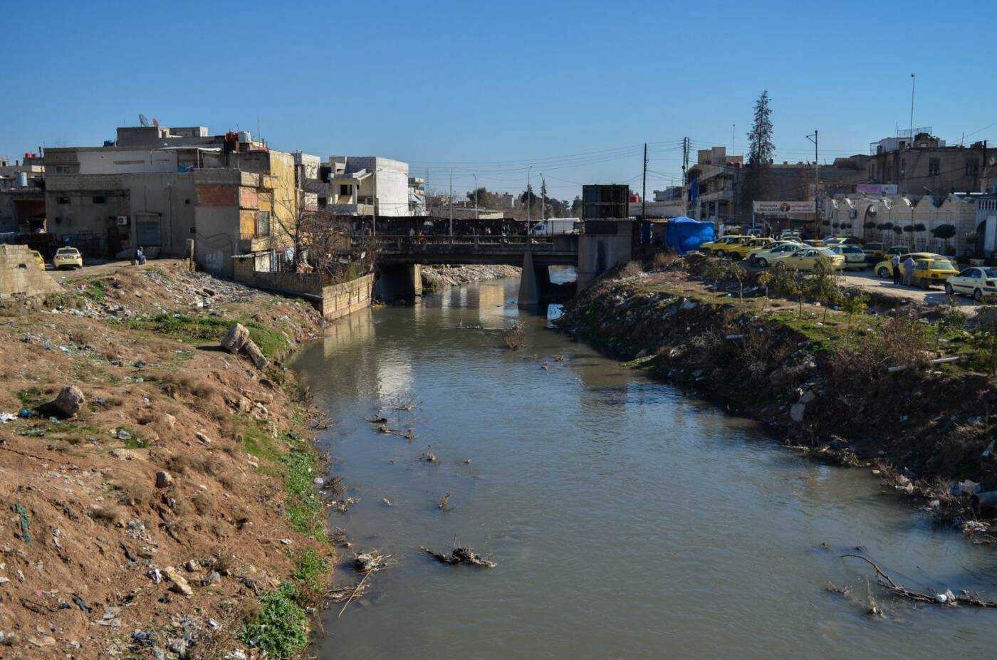
The Jakjak River flows again through the northeastern Syrian city of Qamishli, 12/2/2023(Lyse Mauvais/Syria Direct)
But in some cases, the information shared online by local observers was blown out of proportion, with social media users relaying absurd claims that had no scientific basis. “The opening of the giant Atatürk Dam will have an impact in Syria, Iraq and the Gulf states. It is expected that fish will increase in Kuwait and the Gulf as the sweet river water mixes with salty sea water,” one user tweeted.
“[There are a] lot of claims on social media right now about Turkish dams and the Euphrates or Tigris water levels rising in Syria and Iraq,” Alexander McKeever, an open-source investigator, tweeted on February 10. “So far, I’ve seen no convincing evidence of these. All that’s confirmed is that makeshift earthen dams on the Khabour broke.”
The makeshift dams he referred to were built in the summer of 2021 in areas controlled by Turkish-backed Syrian opposition factions on the Khabour river and its tributaries, likely to capture additional irrigation water at the height of a historic drought. The natural flow of the Khabour, which severely decreased in the 1990s after the river’s main springs in Ras al-Ain dried due to over pumping, was entirely cut after these dams were built, depriving farmers downstream of water.
But rising water levels in some of Syria’s rivers were not only linked to the collapse of dams upstream. The February 6 earthquake also coincided with several days of snow and rain that naturally increased the volume of Turkish and Syrian rivers, as is the case every winter.
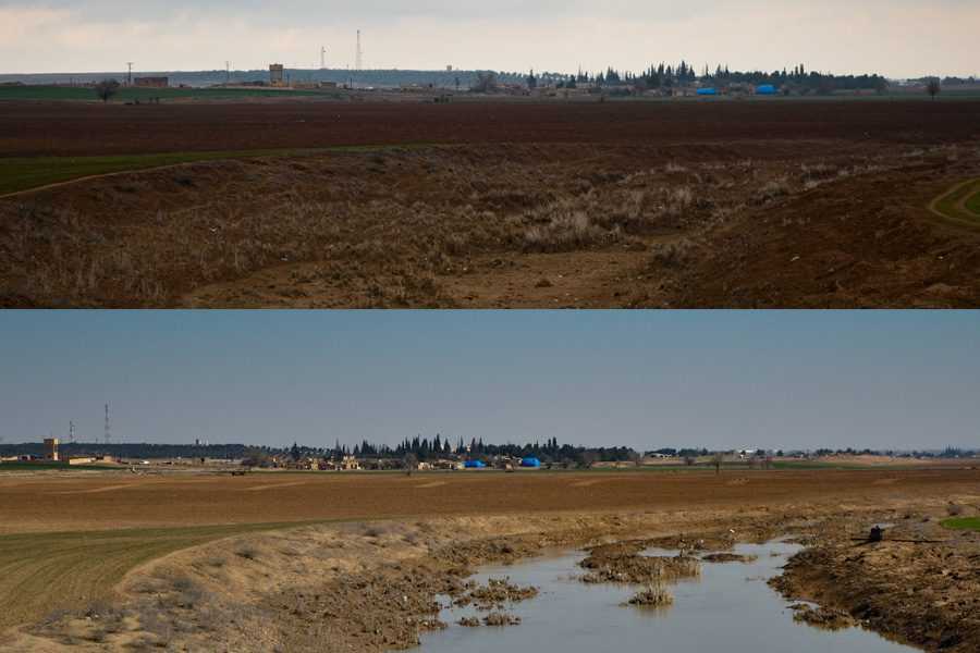
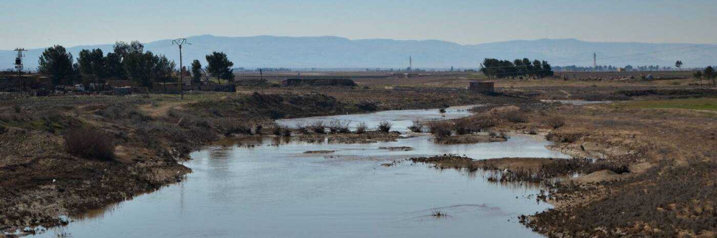
A view of the Khabour river flowing south of Tal Tamar on February 2, 2023, four days before the earthquake (top) and on February 12, six days after it (bottom), (Lyse Mauvais/Syria Direct)
It is common for angst and fear to sweep across communities affected by natural disasters. As dramatic events unfold in close succession, conflicting information is shared and rumors rise from the chaos.
In the hours and days following the devastating earthquakes in Syria and Turkey, some narratives spread about dams and flooding in both countries that turned out to be exaggerated or baseless. Still, 10 days after the disaster, much work remains to be done to scientifically assess its full impact on Syria’s waterways and makeshift dams.